© Photo: Oberösterreich Tourismus GmbH./Robert Maybach: Enjoy the view in Upper Austria


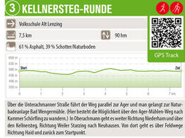
Kellnersteg-Runde


- Flatly
Interactive elevation profile
Create PDF
Tour-Details
Path number: 3
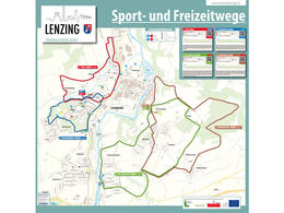
Starting place: 4860 Lenzing
Destination: 4860 Lenzing
duration: 1h 48m
length: 7,2 km
Altitude difference (uphill): 40m
Altitude difference (downhill): 40m
Lowest point: 468m
Highest point: 505m
difficulty: medium
condition: medium
panoramic view: Some Views
powered by TOURDATA
Starting point: Alt Lenzing primary school | 5 km | 50 m altitude difference
In Oberachmann, continue towards Niederham and over the Kellnersteg towards the hamlet of Starzing to Neuhausen. From there, the route continues along field paths towards Haid and back to the starting point.
Parking
- Parking space: 5
Most economical season
- Spring
- Summer
- Autumn
- Early winter
Please get in touch for more information.
")
Alt-Lenzing 31
4860 Lenzing
Phone +43 7672 92955 - 0
E-Mail marktgemeinde@lenzing.or.at
Web www.lenzing.ooe.gv.at
Web attersee-attergau.salzkammergut.at
http://www.lenzing.ooe.gv.at
https://attersee-attergau.salzkammergut.at
https://attersee-attergau.salzkammergut.at
")
Interactive elevation profile
Create PDF
Tour-Details
Path number: 3
Starting place: 4860 Lenzing
Destination: 4860 Lenzing
duration: 1h 48m
length: 7,2 km
Altitude difference (uphill): 40m
Altitude difference (downhill): 40m
Lowest point: 468m
Highest point: 505m
difficulty: medium
condition: medium
panoramic view: Some Views
powered by TOURDATA