

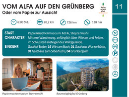
Vom ALFA auf den Grünberg - Traunsee-Almtal Wanderspass


- Suitable for families
- culinary interesting
- culturally interesting
- Possible accommodation
Interactive elevation profile
Create PDF
Tour-Details
Paths covering:
Or from paper to the view
weir - left again over Traunsteg, continue towards Laakirchen - after 500 metres
left via Arbeiterheimstraße and Stifterstraße into Laakirchen town centre (3.2 km
- 1 hour). On the Gmundnerstraße southwards, in Häuslfeld (car dealership Schus-
left at Häuslfeld (Schuster car dealership) and along the Reichering estate road to 16 Wirt am Bach (2.7 km - 30 min,
hiking stamp).
Continue on the Laa goods road, turn right onto Kirchenweg to Schweigthal, then left onto Gschwandtnerstraße, right on this road and after 500 metres left via "In der Edt" and "Unterndorf" to Gschwandt (4.6 km - 1:10 hours).
Short ascent to the Rabesberg and on to 01 GH Wurzenhütte (3.2 km - 1 hour, hiking stamp).
Via Flachberg to "Im Holz" - 02 GH Silberfuchs (2.6 km - 45 min., hiker's stamp) and on forest road via Radmoos to Grünberg / 04 Grünbergalm (3.9 km - 1:35 -hour, hiker's stamp).
We recommend travelling by public transport!
By bus:
OÖVV line 505 stop Steyermühl Papierfabrik
or OÖVV line 520 stop Steyrermühl Traunbrücke
Return journey from Grünberg:
to Gmunden with the Grünberg cable car, with the Traunseetram either to Rathausplatz and continue with the OÖVV bus 505 or to the Kirchham stop and continue with the Salzkammergut Shuttle Service line 52 (only if there is no OÖVV bus connection). Call +43 (0) 50 - 422 422 at least 1 half an hour before the start of the journey and order!
Bike & Hike, travelling by bike:
Coming from Wels or Linz on the R 4 Traunradweg or from Gmunden R 4 Traunradweg or from Passau via Vöcklabruck and Schwanenstadt on the R 6 Römerradweg to Lambach, as far as the ALFA cultural centre in Steyermühl.
Also via the cycle connection R 13 Traunviertlerradweg Pettenbach via Kirchham to Laakirchen.
By car:
The car park at ALFA Steyrermühl is very close to the Laakirchen Ost motorway exit, from there take the B 144 towards Gmunden, turn right towards Ohlsdorf in the dip in Steyrermühl and turn right again before the Traun bridge to ALFA.
- Parking space: 100
- Suitable for groups
- Suitable for seniors
- Suitable for families
- Suitable for friends
- Suitable for couples
- Spring
- Summer
- Autumn
Please get in touch for more information.
4663 Laakirchen
Phone +43 7612 74451
Fax machine +43 7612 71410
E-Mail info@traunsee-almtal.at
Web www.traunsee-almtal.at
Web www.wander-spass.at
http://www.wander-spass.at
Interactive elevation profile
Create PDF
Tour-Details
Paths covering: