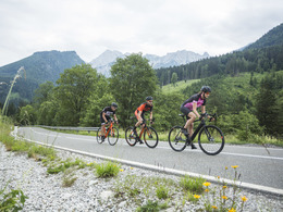
© Photo: Oberösterreich Tourismus GmbH./Robert Maybach: Enjoy the view in Upper Austria


Garstnertal Gourmet Round RR5


- Flatly
Interactive elevation profile
Create PDF
Tour-Details
Path number: RR 5 (nicht beschildert)
Starting place: 4580 Windischgarsten
Destination: 4580 Windischgarsten
duration: 1h 30m
length: 41,0 km
Altitude difference (uphill): 850m
Altitude difference (downhill): 860m
Lowest point: 530m
Highest point: 910m
difficulty: medium
condition: medium
panoramic view: Great panorama
Paths covering:
Asphalt
powered by TOURDATA
The romantic landscape tour.
If you still haven't had enough, you can optionally take on the Wurbauerkogel (3 km/250 metres in altitude).
Starting point: Windischgarsten sports field
Destination: Windischgarsten sports field
further information:
- Flatly
Accessibility / arrival
Start this tour at the soccer field in Windischgarsten (free parking).
- Suitable for teenagers
- Suitable for single travelers
- Suitable for friends
- Suitable for couples
- Spring
- Summer
- Autumn
Please get in touch for more information.
Bahnhofstraße 2
4580 Windischgarsten
Phone +43 7562 5266
Fax machine +43 7562 5266 - 10
E-Mail info@pyhrn-priel.net
Web www.urlaubsregion-pyhrn-priel.at
https://www.urlaubsregion-pyhrn-priel.at
")
")

")
")
")
Interactive elevation profile
Create PDF
Tour-Details
Path number: RR 5 (nicht beschildert)
Starting place: 4580 Windischgarsten
Destination: 4580 Windischgarsten
duration: 1h 30m
length: 41,0 km
Altitude difference (uphill): 850m
Altitude difference (downhill): 860m
Lowest point: 530m
Highest point: 910m
difficulty: medium
condition: medium
panoramic view: Great panorama
Paths covering:
Asphalt
powered by TOURDATA