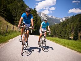
© Photo: Oberösterreich Tourismus GmbH./Robert Maybach: Enjoy the view in Upper Austria


Alpine foothills loop RR6


- Flatly
Interactive elevation profile
Create PDF
Tour-Details
Path number: RR 6 (nicht beschildert)
Starting place: 4573 Hinterstoder
Destination: 4573 Hinterstoder
duration: 4h 30m
length: 114,9 km
Altitude difference (uphill): 1.650m
Altitude difference (downhill): 1.600m
Lowest point: 382m
Highest point: 854m
difficulty: difficult
condition: difficult
panoramic view: Some Views
Paths covering:
Asphalt
powered by TOURDATA
The Alpine foreland loop from Hinterstoder over the Ziehberg to Pettenbach and Schlierbach back again.
Starting point: Parking mountain railways in Hinterstoder
Destination: Parking mountain railways in Hinterstoder
further information:
- Flatly
Accessibility / arrival
Mountain railway car park in Hinterstoder.
- Charging point for electric cars (fees apply)
- Suitable for single travelers
- Suitable for friends
- Suitable for couples
- Spring
- Summer
- Autumn
Please get in touch for more information.
Nr. 38
4573 Hinterstoder
Phone +43 7564 5263
Fax machine +43 7564 5263 - 30
E-Mail hinterstoder@pyhrn-priel.net
Web www.urlaubsregion-pyhrn-priel.at
https://www.urlaubsregion-pyhrn-priel.at

")
")
")
")
")

")

 (© Judmaier Rene)")
")
")
")
")
")

Interactive elevation profile
Create PDF
Tour-Details
Path number: RR 6 (nicht beschildert)
Starting place: 4573 Hinterstoder
Destination: 4573 Hinterstoder
duration: 4h 30m
length: 114,9 km
Altitude difference (uphill): 1.650m
Altitude difference (downhill): 1.600m
Lowest point: 382m
Highest point: 854m
difficulty: difficult
condition: difficult
panoramic view: Some Views
Paths covering:
Asphalt
powered by TOURDATA