© Photo: Oberösterreich Tourismus GmbH./Robert Maybach: Enjoy the view in Upper Austria


Die Waldluftbade-Gesundheitstour


- All weather
- Suitable for families
- Flatly
Interactive elevation profile
Create PDF
Tour-Details
Path number: Spüren. Stärken. Selbst sein
Starting place: 4240 Freistadt
Destination: 4240 Freistadt
duration: 50h 58m
length: 170,7 km
Altitude difference (uphill): 4.492m
Altitude difference (downhill): 4.553m
Lowest point: 306m
Highest point: 1.005m
difficulty: easy
condition: medium
panoramic view: Some Views
Paths covering:
Hiking trail, Other
powered by TOURDATA
information: Akutmeldung/Information
roadblock: asfinag Tunnelbau Vierzehn
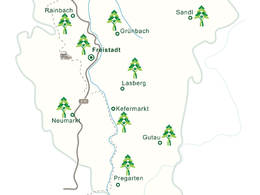
since 01.01.2024 The forest air bathing health tour
Feel - strengthen - be yourself - enjoy the Mühlviertel forest air bathing in the forests and places of strength. The forest air bathing health tour is a circular route covering around 170 kilometres through the Mühlviertler Alm Freistadt region from the Maltsch in the north to the confluence of the Feldaist and Waldaist rivers in the south. Along the way, there are 33 local forest air bathing trails in 12 certified forest air bathing communities. They lead through the enchanting landscapes of the Lower Mühlviertel.
The individual tours in the 12 certified forest air bathing communities can be found HERE.
We follow the meditation trail to St.Peter and the health tour northwards into the Feldaisttal valley. We reach the horse-drawn railway town of Rainbach. From here, three forest trails branch off to the south through the wooded Jaunitztal valley, to the east through the Birau forest area to the Heidenstein in the village of Eibenstein and to the north. We make a detour to the Heidenstein and then follow the path northwards through the village of Kerschbaum and past the horse-drawn railway museum. We walk along the state border through the border forests of Leopoldschlag. In Wullowitz we find the Tobau moorland forest. Moorland forests have a very special effect on us, we should take a "forest nap" here. Shortly afterwards we reach the Maltsch. The woodland along the naturally flowing border river also has a very special effect on people and invites you to linger. Once we reach the market town of Leopoldschlag, two forest trails start here, leading eastwards to the border forests and southwards to the Leopoldschlägerberg, the Reisingerberg and to Hammern and Zettwing on the Maltsch. We follow this path and branch off at Reisingerberg to Windhaag bei Freistadt . In the village of the Green Belt Centre, two forest air bathing trails start to the east to the Reisingerberg and to the west over the Waschenberg into the Plochwald. We follow the latter on our health tour into the Freiwald forest. We hike over the Hundsberg at the foot of the Viehberg to Sandl and further south through Mitterbach and the Weinbergholz until we reach St. Michael. The little church in Rauchenödt is the strongest place of strength on the health tour. We reach Grünbach via the forests of the Heinrichschlägerberg. Three forest bathing trails lead through the municipality to St. Michael, to Lichtenau and to the Feldaist. We follow the latter through the Thurytal valley along the Feldaist back to Freistadt.
We now leave Freistadt to the east towards the Zelletau forest area and walk southwards through the forests of the Haugenödtberg and Koppenberg to Lasberg. Lasberg has three forest trails to the south-eastern hilltop area, to the northern wooded highlands and to the Dornach castle ruins in the west. The latter is a shortcut to the health tour to Kefermarkt. However, we follow the health tour over the Buchberg and the Braunberg through the charming hilltop country, which continues in the villages of Fürling and Erdmannsdorf in the municipality of Gutau. The blueprinting and dyeing community has three forest air bathing trails in the municipality. The path just walked into the northern hilltop country, through the ravine forests of the Waldaist to the ruins of Prandegg Castle and over the wooded heights of Hundsberg, Gutenbrunnerberg and Gaisruckberg to Reichenstein. From Gutau we hike through the Waldaist-Naarn European nature reserve to Reichenstein and from there to the village of Tragwein. This municipality has three forest bathing paths along the Kettenbach, to the Greisinghof with a detour to Reichenstein and to the southernmost point of the health tour to Hohensteg to the confluence of the Feldaist and Waldaist rivers to form the Aist. We follow this and enjoy the spectacle of the marriage of the two very different river personalities. We then head northwards again through the Feldaisttal nature reserve to Pregarten. In Pregarten, three forest trails lead to the southern and northern Feldaisttal valleys and through deep creek cuts and ravine forests to the ruins of Reichenstein Castle. We follow the Feldaist upstream to the north, past the Pienkenhof nature trail and along the wooded ridge of the village of Harterleiten to Kefermarkt. The market town with its famous Gothic winged altar and Weinberg Castle has three forest trails to the north to Buchberg, to Elz and back through the enchanting Flanitztal valley, to the east to Luchsberg and to the south to the Feldaist and the Pienkenhof nature trail. In Kefermarkt, we head west and cross the Kefermarkt basin to Neumarkt. The southern Waldluftbadeweg from Neumarkt leads through the picturesque Gusental valley, the western one through highlands and over wooded hilltops. We follow this to the Bloßsteinhöfe village of Stiftung, cross the upper Gusental valley and hike through the mountains via the Zeissberg to the Tröllsberg back to Freistadt.
Starting point: The large circular route of the Waldluftbaden health tour can be started in any of the 12 municipalities. The hub is the medieval brewing town of Freistadt.
Destination: The large circular route of the Waldluftbaden health tour can be started in any of the 12 municipalities. The hub is the medieval brewing town of Freistadt.
further information:
- Flatly
Details - hiking
- themed path
")
")
")
")
")
")
")
")

")
")
")


Accessibility / arrival
Public transport by train and bus possible
- All weather
- Suitable for groups
- Suitable for seniors
- Suitable for single travelers
- Suitable for families
- Suitable for friends
- Suitable for couples
- Suitable for children
- Spring
- Summer
- Autumn
Please get in touch for more information.
")
Waaggasse 6
4240 Freistadt
Phone +43 5 07263 - 301
E-Mail badzell@muehlviertel.at
Web www.muehlviertel.at
Web www.muehlviertel-urlaub.at
https://www.muehlviertel.at
https://www.muehlviertel-urlaub.at
https://www.muehlviertel-urlaub.at
")
")
")
")
")
")
")
")


")
")
")

")

")


")


")
")
")
")
")

")
")
")
")
")
")
")
")

Interactive elevation profile
Create PDF
Tour-Details
Path number: Spüren. Stärken. Selbst sein
Starting place: 4240 Freistadt
Destination: 4240 Freistadt
duration: 50h 58m
length: 170,7 km
Altitude difference (uphill): 4.492m
Altitude difference (downhill): 4.553m
Lowest point: 306m
Highest point: 1.005m
difficulty: easy
condition: medium
panoramic view: Some Views
Paths covering:
Hiking trail, Other
powered by TOURDATA