© Photo: Oberösterreich Tourismus GmbH./Robert Maybach: Enjoy the view in Upper Austria


Rieser round - "The Sunny"


- Suitable for families
- Flatly
Interactive elevation profile
Create PDF
Tour-Details
Starting place: 4574 Vorderstoder
Destination: 4574 Vorderstoder
duration: 1h 30m
length: 4,2 km
Altitude difference (uphill): 157m
Altitude difference (downhill): 157m
Lowest point: 781m
Highest point: 940m
difficulty: easy
condition: easy
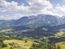
panoramic view: Great panorama
Paths covering:
Asphalt, Gravel, Hiking trail, Other
powered by TOURDATA
We turn left at the Steinerstadel and walk as long as the signs until we get to a wooden bridge over the Schneckenbach. A steep, newly built staircase now facilitates the ascent. Continue on across meadows, passing farms and the farm Mittermair. Bankerl on the way invite you to rest and we can enjoy the sun and the fantastic view.
Starting point: Municipal office Vordestoder
Destination: Municipal office Vordestoder
further information:
- Flatly
Accessibility / arrival
Start and finish is located directly in the local center of Vorderstoder at the municipal office.
- Suitable for groups
- Suitable for schools
- Suitable for teenagers
- Suitable for seniors
- Suitable for single travelers
- Suitable for families
- Suitable for friends
- Suitable for couples
- Suitable for children
- Spring
- Summer
- Autumn
Please get in touch for more information.

Nr. 66
4574 Vorderstoder
Phone +43 7564 8255
Fax machine +43 7564 8255 - 20
E-Mail vorderstoder@pyhrn-priel.net
Web www.urlaubsregion-pyhrn-priel.at
https://www.urlaubsregion-pyhrn-priel.at
")
")
Interactive elevation profile
Create PDF
Tour-Details
Starting place: 4574 Vorderstoder
Destination: 4574 Vorderstoder
duration: 1h 30m
length: 4,2 km
Altitude difference (uphill): 157m
Altitude difference (downhill): 157m
Lowest point: 781m
Highest point: 940m
difficulty: easy
condition: easy
panoramic view: Great panorama
Paths covering:
Asphalt, Gravel, Hiking trail, Other
powered by TOURDATA