© Photo: Oberösterreich Tourismus GmbH./Robert Maybach: Enjoy the view in Upper Austria


Steyrsbergerreith round - "The Quaint One"
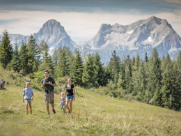


- Suitable for families
- Suitable for pushchairs
- Flatly
Interactive elevation profile
Create PDF
Tour-Details
Starting place: 4574 Vorderstoder
Destination: 4574 Vorderstoder
duration: 3h 30m
length: 12,4 km
Altitude difference (uphill): 497m
Altitude difference (downhill): 504m
Lowest point: 743m
Highest point: 1.160m
difficulty: easy
condition: easy
panoramic view: Great panorama
Paths covering:
Asphalt, Gravel, Hiking trail, Other
powered by TOURDATA
We turn right after the Schaffergut and after a short distance left into the Hammerlgraben. Along the wild and romantic Loigis and in the cool shade of the trees we hike slightly uphill. Soon we reach the parking lot Schafferteich. From there, the forest road is also suitable for all-terrain stroller - but you have to take the same way to the parking lot back down.
We continue on the forest road to the mountain rescue hut, for the thirst there is a well here. Keeping on the forest road we come to Reith. With homemade delicacies spoiled the family Platzer all visitors (opening hours note) and has for each a friendly word. The view of the Dead Mountains is a dream and it is difficult to separate again from this place of power. The descent takes us mostly through the forest to the property Baumschlagerberg. From there it goes on a tarred road further down the valley, past several farms. Shortly before the sawmill Hackl turn right over a small bridge, which leads across the Loigis, to the Stoderer forest and water playground "Swuwiz". After a short stretch of forest you reach the Vorderstoderer Landesstraße and back to the village.
Starting point: Municipal office Vorderstoder
Destination: Municipal office Vorderstoder
further information:
- Flatly
Accessibility / arrival
Start and finish is located directly in the local center of Vorderstoder at the municipal office.
- Suitable for groups
- Suitable for schools
- Suitable for pushchairs
- Suitable for teenagers
- Suitable for seniors
- Suitable for single travelers
- Suitable for families
- Suitable for friends
- Suitable for couples
- Suitable for children
- Spring
- Summer
- Autumn
Please get in touch for more information.

Nr. 66
4574 Vorderstoder
Phone +43 7564 8255
Fax machine +43 7564 8255 - 20
E-Mail vorderstoder@pyhrn-priel.net
Web www.urlaubsregion-pyhrn-priel.at
https://www.urlaubsregion-pyhrn-priel.at
")
Interactive elevation profile
Create PDF
Tour-Details
Starting place: 4574 Vorderstoder
Destination: 4574 Vorderstoder
duration: 3h 30m
length: 12,4 km
Altitude difference (uphill): 497m
Altitude difference (downhill): 504m
Lowest point: 743m
Highest point: 1.160m
difficulty: easy
condition: easy
panoramic view: Great panorama
Paths covering:
Asphalt, Gravel, Hiking trail, Other
powered by TOURDATA