© Photo: Oberösterreich Tourismus GmbH./Robert Maybach: Enjoy the view in Upper Austria


Waldluftbadeweg Luchsberg


- All weather
- Flatly
Interactive elevation profile
Create PDF
Tour-Details
Path number: Route mit roten Legenden
Starting place: 4292 Kefermarkt
Destination: 4292 Kefermarkt
duration: 1h 14m
length: 4,0 km
Altitude difference (uphill): 124m
Altitude difference (downhill): 127m
Lowest point: 505m
Highest point: 580m
difficulty: easy
condition: easy
panoramic view: No view
Paths covering:
Hiking trail, Other
powered by TOURDATA
Forest air bathing in Kefermarkt
Kefermarkt is located in the Central Mühlviertel highlands. With the village of Harterleiten, the Aist-Naarn-Kuppenland still extends into the municipal area. Kefermarkt is part of several landscape organisms: the Freistädter Becken, the Kefermarkter Becken, the Kuppenland of Gutau / Lasberg and the Hochland of Neumarkt / Hagenberg. The centre of the Kefermarkt local organism is the vineyard, the effect of which is further enhanced by the nearby Buchberg. The village is famous for its pilgrimage church with its Gothic winged altar and the Weinberg Castle standing guard above it at the intersection of three landscape organisms.
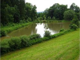
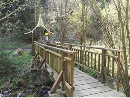
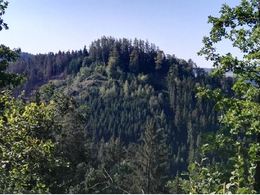
The route largely follows the K30 hiking trail. The Luchsberg (mountain peak 516 m) is the final rock in the Harterleiten area and is almost encircled by the Flanitz. The 0.75-hectare Flanitzteich pond in the beautiful, idyllic Flanitztal valley is located at its access point at the eastern end of Kefermarkt. The "Pendellehrpfad" theme trail, which begins a circular route around the Luchsberg, starts at the same access point. The trail leads us via the "Dreifrauenplatz" and the "Blaue Quelle" (Blue Spring) at the northern foot of the mountain.
Luchsberg forest air bathing trail - waypoints
1. hiking stone
2. flanitz pond
3. pendulum nature trail
4. Dreifrauenplatz
5. blue spring
For guided tours, please contact our qualified forest air bathing instructors - you can find more information here.
Starting point: Wanderstein town square
Destination: Wanderstein town square
further information:
- Flatly
Details - hiking
- themed path
")

- All weather
- Suitable for groups
- Suitable for schools
- Suitable for teenagers
- Suitable for seniors
- Suitable for single travelers
- Suitable for friends
- Suitable for couples
- Spring
- Summer
- Autumn
- Early winter
Please get in touch for more information.

Oberer Markt 15
4240 Freistadt
Phone +43 7947 5910 - 0
E-Mail gemeinde@kefermarkt.ooe.gv.at
Web www.kefermarkt.ooe.gv.at
Web www.waldluftbaden.at
http://www.kefermarkt.ooe.gv.at
http://www.waldluftbaden.at
http://www.waldluftbaden.at
Interactive elevation profile
Create PDF
Tour-Details
Path number: Route mit roten Legenden
Starting place: 4292 Kefermarkt
Destination: 4292 Kefermarkt
duration: 1h 14m
length: 4,0 km
Altitude difference (uphill): 124m
Altitude difference (downhill): 127m
Lowest point: 505m
Highest point: 580m
difficulty: easy
condition: easy
panoramic view: No view
Paths covering:
Hiking trail, Other
powered by TOURDATA