

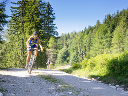
Weißenbachtal tour MTB7


- Suitable for families
- Flatly
Interactive elevation profile
Create PDF
Tour-Details
Paths covering:
Small but beautiful mountain bike tour through the Weißenbachtal valley.
PLEASE NOTE: the tour is signposted from 2026 from the cable car car park. Until then, please follow the main road from the cable car car park into the valley until the turn-off to the left into the Weißenbachtal valley.
further information:
- Flatly
details mountainbike
- Riding technique: easy
Cycling and mountain biking is allowed from April 15th to October 31st 2 hours after sunrise to 1 hour before sunset and is only allowed on marked routes. Some bike paths are also designated as hiking trails or bridle paths. Always count on oncoming hikers or riders!
Free parking at the large cable car car park at the entrance to Hinterstoder.
From here you cycle approx. 4.5km into the valley to the starting point of the Weißenbachtaltour.
The large cable car car park at the entrance to Hinterstoder is free of charge. All other car parks in Hinterstoder are subject to a charge.
E-service station / recharging station- Charging point for electric cars (fees apply)
- Suitable for seniors
- Suitable for single travelers
- Suitable for families
- Suitable for friends
- Suitable for couples
- Spring
- Summer
- Autumn
Please get in touch for more information.
Hinterstoder 38
4573 Hinterstoder
Phone +43 7564 5263
Fax machine +43 7564 5263 - 30
E-Mail info@pyhrn-priel.net
Web www.urlaubsregion-pyhrn-priel.at/

")
")
")
")
")
")

")
")
")
")
Interactive elevation profile
Create PDF
Tour-Details
Paths covering: