© Photo: Oberösterreich Tourismus GmbH./Robert Maybach: Enjoy the view in Upper Austria


S18 Weißenbacher delicacies round


Interactive elevation profile
Create PDF
Tour-Details
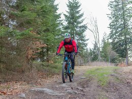
Path number: S 18
Starting place: 4190 Vorderweißenbach
Destination: 4190 Bad Leonfelden
duration: 1h 51m
length: 23,7 km
Altitude difference (uphill): 385m
Altitude difference (downhill): 387m
Lowest point: 662m
Highest point: 892m
difficulty: medium
condition: medium
panoramic view: Great panorama
Paths covering:
Asphalt, Gravel, Street
powered by TOURDATA
General price information
free
Most economical season
- Spring
- Summer
- Autumn
Please get in touch for more information.
Hauptplatz 19
4190 Bad Leonfelden
Phone +43 5 07263 - 101
E-Mail badleonfelden@muehlviertel.at
Web www.muehlviertel.at
https://www.muehlviertel.at
")
")

")
")
")
")
Interactive elevation profile
Create PDF
Tour-Details
Path number: S 18
Starting place: 4190 Vorderweißenbach
Destination: 4190 Bad Leonfelden
duration: 1h 51m
length: 23,7 km
Altitude difference (uphill): 385m
Altitude difference (downhill): 387m
Lowest point: 662m
Highest point: 892m
difficulty: medium
condition: medium
panoramic view: Great panorama
Paths covering:
Asphalt, Gravel, Street
powered by TOURDATA