© Photo: Oberösterreich Tourismus GmbH./Robert Maybach: Enjoy the view in Upper Austria


S4 Bankerlsteig


Interactive elevation profile
Create PDF
Tour-Details
Path number: S4
Starting place: 4170 St. Stefan-Afiesl
Destination: 4170 St. Stefan-Afiesl
duration: 1h 46m
length: 6,2 km
Altitude difference (uphill): 136m
Altitude difference (downhill): 137m
Lowest point: 758m
Highest point: 899m
difficulty: medium
condition: medium
panoramic view: Some Views
Paths covering:
Hiking trail
powered by TOURDATA
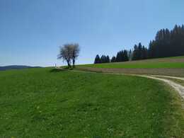
The beautiful hike leads through the spray forest in Steffingen and gives hiking and resting a whole new meaning.
Marking: with the number S4Map download: S4 Bankerlsteig
Starting point: St. Stefan town square - Afiesl
Destination: St. Stefan town square - Afiesl
General price information
free
Most economical season
- Spring
- Summer
- Autumn
Please get in touch for more information.
Hauptplatz 19
4190 Bad Leonfelden
Phone +43 5 07263 - 101
E-Mail badleonfelden@muehlviertel.at
Web www.muehlviertel.at
https://www.muehlviertel.at
")
")
")


")
Interactive elevation profile
Create PDF
Tour-Details
Path number: S4
Starting place: 4170 St. Stefan-Afiesl
Destination: 4170 St. Stefan-Afiesl
duration: 1h 46m
length: 6,2 km
Altitude difference (uphill): 136m
Altitude difference (downhill): 137m
Lowest point: 758m
Highest point: 899m
difficulty: medium
condition: medium
panoramic view: Some Views
Paths covering:
Hiking trail
powered by TOURDATA