© Photo: Oberösterreich Tourismus GmbH./Robert Maybach: Enjoy the view in Upper Austria


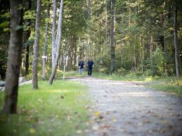
S10 Weitblick Weg


Interactive elevation profile
Create PDF
Tour-Details
Path number: S10
Starting place: 4170 St. Stefan-Afiesl
Destination: 4170 St. Stefan-Afiesl
duration: 0h 57m
length: 3,5 km
Altitude difference (uphill): 56m
Altitude difference (downhill): 61m
Lowest point: 833m
Highest point: 888m
difficulty: medium
condition: medium
panoramic view: Great panorama
Paths covering:
Hiking trail
powered by TOURDATA
Route:
Hotel Bergergut - across meadows and forest paths - panoramic view - Güterweg- Hotel Bergergut
Map download: S10 Weitblick Weg
Starting point: Hotel Bergergut
Destination: Hotel Bergergut
General price information
free
Most economical season
- Spring
- Summer
- Autumn
Please get in touch for more information.
Hauptplatz 19
4190 Bad Leonfelden
Phone +43 5 07263 - 101
E-Mail badleonfelden@muehlviertel.at
Web www.muehlviertel.at
https://www.muehlviertel.at
")
")
")


")
")
Interactive elevation profile
Create PDF
Tour-Details
Path number: S10
Starting place: 4170 St. Stefan-Afiesl
Destination: 4170 St. Stefan-Afiesl
duration: 0h 57m
length: 3,5 km
Altitude difference (uphill): 56m
Altitude difference (downhill): 61m
Lowest point: 833m
Highest point: 888m
difficulty: medium
condition: medium
panoramic view: Great panorama
Paths covering:
Hiking trail
powered by TOURDATA