© Photo: Oberösterreich Tourismus GmbH./Robert Maybach: Enjoy the view in Upper Austria


Wolfgang Kölblinger Runde by Runnersfun


Interactive elevation profile
Create PDF
Tour-Details
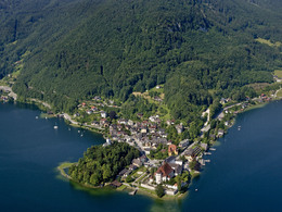
Starting place: 4801 Traunkirchen
Destination: 4801 Traunkirchen
duration: 1h 3m
length: 4,0 km
Altitude difference (uphill): 53m
Altitude difference (downhill): 47m
Lowest point: 423m
Highest point: 476m
difficulty: easy
condition: very easy
panoramic view: Individual Views
Paths covering:
Asphalt
powered by TOURDATA
Bewegungsarena Traunkirchen - Wolfgang Kölblinger loop - blue
The "Wolfgang Kölblinger Runde" starts at the Bräuwiese, leads past the former Buchberg hospital and through the Hofgraben. The route continues through a shady section of forest along the Mühlbach stream, between meadows, fields and well-kept cattle farms towards Buchberg, leaving it to the right and returning to the starting point. Most economical season
- Spring
- Summer
- Autumn
- Early winter
- Deep winter
Please get in touch for more information.

Krottenseestraße 45
4810 Gmunden
Phone +43 7612 20822
E-Mail office@runnersfun.com
Web www.runnersfun.com/
http://www.runnersfun.com/
Interactive elevation profile
Create PDF
Tour-Details
Starting place: 4801 Traunkirchen
Destination: 4801 Traunkirchen
duration: 1h 3m
length: 4,0 km
Altitude difference (uphill): 53m
Altitude difference (downhill): 47m
Lowest point: 423m
Highest point: 476m
difficulty: easy
condition: very easy
panoramic view: Individual Views
Paths covering:
Asphalt
powered by TOURDATA