© Photo: Oberösterreich Tourismus GmbH./Robert Maybach: Enjoy the view in Upper Austria


Irrsee mountainbike tour
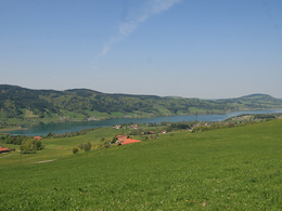


 | © TVB Mondsee-Irrsee_Valentin Weinhäupl")


- Flatly
Interactive elevation profile
Create PDF
Tour-Details
Path number: S530
Starting place: 5310 Mondsee am Mondsee
Destination: 5310 Mondsee am Mondsee
duration: 5h 10m
length: 58,6 km
Altitude difference (uphill): 1.507m
Altitude difference (downhill): 1.507m
Lowest point: 482m
Highest point: 958m
difficulty: medium
condition: medium
panoramic view: Some Views
Paths covering:
Asphalt, Gravel, Other
powered by TOURDATA
This mountain bike tour takes you in a wide arc around the Irrsee, where we can enjoy great views all over the lake!
Through the large avenue of lime trees it goes to the lake promenade and along the lake. At the roundabout we take the first exit and continue in the direction of Thalgau. After a piece of forest on the left-hand side, we turn right, cross a stream and now drive up to the Gaisberg. Arriving at the top/in the settlement we turn left and drive under the highway. At the next crossroads we keep to the right and get to the Erlachmühle. We leave this behind and turn left at the junction. This is how we get to the settlement area of Weißenstein, cross the main road here and continue uphill to the Guggenberg. We follow a sharp left turn and immediately after that a right turn and come to Lackenberg and on towards Mondseeberg/Hochmoor. We are now in a dense forest area and after a while we come to Saurüssel, Kropfbaumsink and the train station. In a northerly direction we continue to the hamlets of Angern, Jagdhub and Pölzleiten. We circumnavigate half of the Kogler Berg and come to Oberhofen am Irrsee. From here it goes uphill again, in the direction of Höhenroith and Sommerholz. Over the ridge of the Kolomansberg we now go straight ahead through the forest in a southerly direction for a long time. In Schernthan we turn right and come out of the forest again. Via Buchschach am Thalgauberg it goes downhill to Vetterbach and then always south of the main road back to Mondsee. Starting point: Mondsee-Irrsee Tourism Association, Dr. Franz Müller Strasse 3, 5310 Mondsee
Destination: Mondsee-Irrsee Tourism Association, Dr. Franz Müller Strasse 3, 5310 Mondsee
further information:
- Flatly
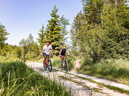
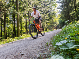
details mountainbike
- Riding technique: easy
Accessibility / arrival
Accessibility:
arrival by car:
From Germany: Coming from Munich on the A8 in the direction of Salzburg, then on the A1 in the direction of Linz/Vienna. After 30 kilometers, take the Mondsee exit.
from Vienna: drive on the A1 in the direction of Salzburg to the Mondsee exit.
from Italy: take the A10 to Salzburg, there you turn onto the A1 in the direction of Linz/Vienna, after 30 kilometers you take the Mondsee exit.
by train:
Strasswalchen train station – 14 km to Mondsee (public bus)
or
Salzburg train station – 30 km to Mondsee (public bus)
The tour starts in the center of Mondsee, at the tourist office. There are free parking spaces, for example, on the Mondsee lake promenade.
- Parking space: 100
none
E-service station / recharging station- Charging point for e-bikes (free of charge)
- Suitable for seniors
- Suitable for single travelers
- Suitable for friends
- Suitable for couples
- Spring
- Summer
- Autumn
Please get in touch for more information.
")
Dr. Franz Müller Str. 3
5310 Mondsee am Mondsee
Phone +43 6232 2270
Fax machine +43 6232 2270 - 22
E-Mail info@mondsee.at
Web mondsee.salzkammergut.at/
https://mondsee.salzkammergut.at/
")
")
")
Interactive elevation profile
Create PDF
Tour-Details
Path number: S530
Starting place: 5310 Mondsee am Mondsee
Destination: 5310 Mondsee am Mondsee
duration: 5h 10m
length: 58,6 km
Altitude difference (uphill): 1.507m
Altitude difference (downhill): 1.507m
Lowest point: 482m
Highest point: 958m
difficulty: medium
condition: medium
panoramic view: Some Views
Paths covering:
Asphalt, Gravel, Other
powered by TOURDATA