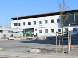
© Photo: Oberösterreich Tourismus GmbH./Robert Maybach: Enjoy the view in Upper Austria
Rundweg 1 Weinbergstraße


- Flatly
Interactive elevation profile
Create PDF
Tour-Details
Path number: E1
Starting place: 4209 Engerwitzdorf
Destination: 4209 Engerwitzdorf
duration: 2h 17m
length: 8,6 km
Altitude difference (uphill): 110m
Altitude difference (downhill): 115m
Lowest point: 318m
Highest point: 411m
difficulty: medium
condition: medium
panoramic view: Some Views
Paths covering:
Asphalt, Gravel, Street, Hiking trail
powered by TOURDATA
Start at the municipal office, continue in a northerly direction over the Große Gusen and along this towards Gallneukirchen. At the leisure centre in Gallneukirchen (fork in the road), turn right in an easterly direction to Herdaweg and Gusentalstraße (Simling). Follow the pavement along Gusentalstraße in the direction of Engerwitzdorf until you reach Falkenweg, which branches off to the left. Follow this in a northerly direction into the Riedmark housing estate as far as Riedmarkstraße, turn right along this road to WEINBERGSTRASSE (crossroads), continue along the Statzner/Karlinger goods road towards the motorway service area, along Engerwitzdorfweg into the village of Engerwitzdorf and back to Schweinbach.
Most economical season
- Spring
- Summer
- Autumn
Please get in touch for more information.
Leopold-Schöffl-Platz 1
4209 Engerwitzdorf
Phone 7235 66955 - 0
E-Mail gemeinde@engerwitzdorf.gv.at
Web www.engerwitzdorf.gv.at/Leben-in-En…
https://www.engerwitzdorf.gv.at/Leben-in-Engerwitzdorf/Freizeit/Wanderwege
Interactive elevation profile
Create PDF
Tour-Details
Path number: E1
Starting place: 4209 Engerwitzdorf
Destination: 4209 Engerwitzdorf
duration: 2h 17m
length: 8,6 km
Altitude difference (uphill): 110m
Altitude difference (downhill): 115m
Lowest point: 318m
Highest point: 411m
difficulty: medium
condition: medium
panoramic view: Some Views
Paths covering:
Asphalt, Gravel, Street, Hiking trail
powered by TOURDATA
