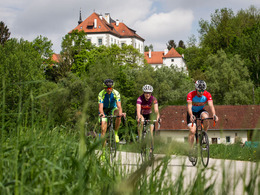
© Photo: Oberösterreich Tourismus GmbH./Robert Maybach: Enjoy the view in Upper Austria


382 Cycle tour "Sportpanorama"


- culinary interesting
- culturally interesting
- Flatly
Interactive elevation profile
Create PDF
Tour-Details
Path number: 382
Starting place: 4540 Bad Hall
Destination: 4540 Bad Hall
duration: 4h 10m
length: 57,0 km
Altitude difference (uphill): 618m
Altitude difference (downhill): 624m
Lowest point: 320m
Highest point: 547m
difficulty: difficult
condition: difficult
panoramic view: Great panorama
Paths covering:
Asphalt
powered by TOURDATA
Although Bad Hall is not "built on hills", it is surrounded by them - to the south they become real mountains, to the north they taper off gently - there is no flat land like around Lake Neusiedl, but there are magnificent panoramic views from the heights into the wide open countryside.
On to Hallerwald, down to Adlwang, steadily up to the ridge of the Kremstal border with the "tree in the middle of the forest" - that's the next section in a nutshell. After Kremsmünster, the route is downhill, through the floodplain to Rohr the headwind is a problem at most, the rest of the route requires a little more "climbing power" again on varied sections in Neukematen and Furtberg.
If you don't want to do the whole loop in one go, there are plenty of refreshment stops, and if the "Hohe Linde" seems too hard, take the gentle shortcut directly from the centre of Waldneukirchen ... Let's go, the journey is the reward!
Our lovely blogger Angelika Mandler-Saul has written a wonderful report about our cycling region, which you can read here!
- Suitable for groups
- Suitable for single travelers
- Suitable for friends
- Suitable for couples
- Spring
- Summer
- Autumn
Please get in touch for more information.
Kurpromenade 1
4540 Bad Hall
Phone +43 7258 7200 - 0
E-Mail info@badhall.at
Web www.badhall.at/
https://www.badhall.at/
Interactive elevation profile
Create PDF
Tour-Details
Path number: 382
Starting place: 4540 Bad Hall
Destination: 4540 Bad Hall
duration: 4h 10m
length: 57,0 km
Altitude difference (uphill): 618m
Altitude difference (downhill): 624m
Lowest point: 320m
Highest point: 547m
difficulty: difficult
condition: difficult
panoramic view: Great panorama
Paths covering:
Asphalt
powered by TOURDATA