© Photo: Oberösterreich Tourismus GmbH./Robert Maybach: Enjoy the view in Upper Austria


Mit dem Rad entlang der Ischl


Interactive elevation profile
Create PDF
Tour-Details
Starting place: 4820 Bad Ischl
Destination: 4820 Bad Ischl
duration: 0h 31m
length: 7,7 km
Altitude difference (uphill): 43m
Altitude difference (downhill): 42m
Lowest point: 466m
Highest point: 502m
difficulty: easy
condition: easy
panoramic view: Individual Views
Paths covering:
Asphalt, Gravel, Street
powered by TOURDATA
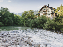
From the Trinkhalle via the Dammweg on the Ischl River to Pfandl and back to the Trinkhalle on the opposite side of the river.
- Suitable for single travelers
- Suitable for couples
- Spring
- Summer
- Autumn
Please get in touch for more information.
Interactive elevation profile
Create PDF
Tour-Details
Starting place: 4820 Bad Ischl
Destination: 4820 Bad Ischl
duration: 0h 31m
length: 7,7 km
Altitude difference (uphill): 43m
Altitude difference (downhill): 42m
Lowest point: 466m
Highest point: 502m
difficulty: easy
condition: easy
panoramic view: Individual Views
Paths covering:
Asphalt, Gravel, Street
powered by TOURDATA