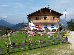
© Photo: Oberösterreich Tourismus GmbH./Robert Maybach: Enjoy the view in Upper Austria


To the Sausteigalm


- Flatly
Interactive elevation profile
Create PDF
Tour-Details
Path number: 854 + 855
Starting place: 5340 St. Gilgen
Destination: 5340 St. Gilgen
duration: 3h 20m
length: 6,7 km
Altitude difference (uphill): 558m
Altitude difference (downhill): 551m
Lowest point: 552m
Highest point: 1.080m
difficulty: medium
condition: medium
panoramic view: Great panorama
powered by TOURDATA
Start: Mozartplatz square St. Gilgen
Pfarrgasse lane - cross the main road - Hochreithstrasse road - follow trail No. 854 via Kühleiten to the Sausteigalm pastures. Return on trail No. 855 via Weißwand to the starting point.
Pfarrgasse lane - cross the main road - Hochreithstrasse road - follow trail No. 854 via Kühleiten to the Sausteigalm pastures. Return on trail No. 855 via Weißwand to the starting point.
Starting point: Mozartplatz square St. Gilgen
Destination: Mozartplatz square St. Gilgen
further information:
- Flatly
Most economical season
- Spring
- Summer
- Autumn
Please get in touch for more information.
Au 140
5360 St. Wolfgang im Salzkammergut
Phone +43 6138 8003
E-Mail info@wolfgangsee.at
Web www.wolfgangsee.at
http://www.wolfgangsee.at
Interactive elevation profile
Create PDF
Tour-Details
Path number: 854 + 855
Starting place: 5340 St. Gilgen
Destination: 5340 St. Gilgen
duration: 3h 20m
length: 6,7 km
Altitude difference (uphill): 558m
Altitude difference (downhill): 551m
Lowest point: 552m
Highest point: 1.080m
difficulty: medium
condition: medium
panoramic view: Great panorama
powered by TOURDATA