© Photo: Oberösterreich Tourismus GmbH./Robert Maybach: Enjoy the view in Upper Austria


109 Kefermarkt round


Interactive elevation profile
Create PDF
Tour-Details
Path number: 109
Starting place: 4292 Kefermarkt
Destination: 4292 Kefermarkt
duration: 3h 4m
length: 35,9 km
Altitude difference (uphill): 824m
Altitude difference (downhill): 823m
Lowest point: 458m
Highest point: 705m
difficulty: medium
condition: difficult
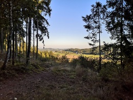
panoramic view: Some Views
Paths covering:
Asphalt, Path / trail, Gravel, Other
powered by TOURDATA
From the car park, cycle along Kefermarkter Straße to the Flanitzteichen ponds and from there follow a forest path steeply uphill.
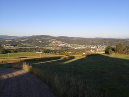
Well warmed up, continue along the so-called Harterleiten, alternating slightly hilly asphalt and meadow paths before rushing down to the Feldaist on a goods road. After crossing this, the second ascent follows up to Dingdorf, along a crisp gravel climb offering great views of the Mühlviertel hills.
On reaching the top, you meet the Neumarkt bike route, which you follow past Matzelsdorf for 4.5 km on varied trails and forest/meadow paths.
On a hill near Wagrein there is a magnificent view of Kefermarkt with its Weinberg castle.
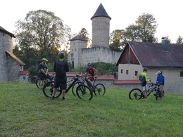
In a wide right-hand bend you cycle on hilly paths just past Freistadt and Lasberg, a short detour to the Dornach castle ruins before following the Lasberg road towards Kefermarkt. Now clench your teeth once again as the route climbs steeply up a forest path to Siegelsdorf. From here, a forest path takes you quickly down to Kefermarkt, the route leads directly past the Schlosstaverne Weinberg with its own brewery, for a well-deserved refreshment, other catering establishments such as Café Stöckl and Café Restaurant Krah await the tired biker in Kefermarkt in the immediate vicinity of the end point of the tour.
Nature is always there for us. So it's only fair that we are there for nature too.
Fair Play Rules for Mountain Biking please be sure to follow them!
Well warmed up, continue along the so-called Harterleiten, alternating slightly hilly asphalt and meadow paths before rushing down to the Feldaist on a goods road. After crossing this, the second ascent follows up to Dingdorf, along a crisp gravel climb offering great views of the Mühlviertel hills.
On reaching the top, you meet the Neumarkt bike route, which you follow past Matzelsdorf for 4.5 km on varied trails and forest/meadow paths.
On a hill near Wagrein there is a magnificent view of Kefermarkt with its Weinberg castle.
In a wide right-hand bend you cycle on hilly paths just past Freistadt and Lasberg, a short detour to the Dornach castle ruins before following the Lasberg road towards Kefermarkt. Now clench your teeth once again as the route climbs steeply up a forest path to Siegelsdorf. From here, a forest path takes you quickly down to Kefermarkt, the route leads directly past the Schlosstaverne Weinberg with its own brewery, for a well-deserved refreshment, other catering establishments such as Café Stöckl and Café Restaurant Krah await the tired biker in Kefermarkt in the immediate vicinity of the end point of the tour.
Nature is always there for us. So it's only fair that we are there for nature too.
Fair Play Rules for Mountain Biking please be sure to follow them!
Starting point: Kefermarkt cemetery car park
Destination: Kefermarkt cemetery car park
Most economical season
- Spring
- Summer
- Autumn
Please get in touch for more information.

Oberer Markt 15
4292 Kefermarkt
Phone +43 7947 5910
E-Mail anfrage@muehlviertel.at
Web www.kefermarkt.ooe.gv.at
Web www.muehlviertel-urlaub.at/bike
http://www.kefermarkt.ooe.gv.at
http://www.muehlviertel-urlaub.at/bike
http://www.muehlviertel-urlaub.at/bike
Interactive elevation profile
Create PDF
Tour-Details
Path number: 109
Starting place: 4292 Kefermarkt
Destination: 4292 Kefermarkt
duration: 3h 4m
length: 35,9 km
Altitude difference (uphill): 824m
Altitude difference (downhill): 823m
Lowest point: 458m
Highest point: 705m
difficulty: medium
condition: difficult
panoramic view: Some Views
Paths covering:
Asphalt, Path / trail, Gravel, Other
powered by TOURDATA