113 Pregarten Runde
Path number: 113
Starting place: 4230 Pregarten
Destination: 4230 Pregarten
Stadtplatz 12
4230 Pregarten
4230 Pregarten

From the starting point at the Pregarten town café, you cycle through housing estates to the eastern edge of the town.
At the Pregarten mini golf course, you leave the tarmac road and follow a relatively steep gravel path that leads you to the Hubertus Chapel. After briefly enjoying the impressive view, you cycle past Pregartsdorf and Hainberg into the beautiful Aisttal valley. If you follow the Feldaist to the north, a "rustic" refreshment stop awaits thirsty cyclists directly on the route at the "Postlschupfn".
Well fortified, you follow the Mühlviertler Mittellandweg 150 to Reichenstein, where a steep gravel descent ends in the Waldaisttal valley at the medieval Reichenstein Castle.
Now the most strenuous section of the route awaits you, pedaling steeply up about 120 m on asphalt. Done!
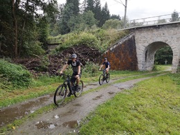
From now on, the route is gently undulating, alternating between asphalt, gravel and forest and meadow paths back to Pregarten, again dotted with beautiful viewpoints. You pass Sport Lehner's outdoor service station on the way back to the main square.
Due to the route, it is possible to shorten the route.
Around 43% of the route is on natural trails, while the remaining 57% is on paved paths and asphalt (17%).
Nature is always there for us. So it is only fair that we are there for nature too.
Please observe the fair play rules for mountain biking!
Path number: 113
Starting place: 4230 Pregarten
Destination: 4230 Pregarten
duration: 2h 28m
length: 29,3 km
Altitude difference (uphill): 648m
Altitude difference (downhill): 647m
Lowest point: 327m
Highest point: 564m
difficulty: medium
condition: difficult
panoramic view: Individual Views
Paths covering:
Asphalt, Path / trail, Gravel, Other
Starting point: Pregarten town square
Destination: Pregarten town square
Most economical season
- Spring
- Summer
- Autumn
Please get in touch for more information.
Stadtplatz 12
4230 Pregarten
Phone +43 7236 2255
E-Mail anfrage@muehlviertel.at
Web www.pregarten.at/
Web www.muehlviertel-urlaub.at/bike
https://www.pregarten.at/
https://www.muehlviertel-urlaub.at/bike
https://www.muehlviertel-urlaub.at/bike


