© Photo: Oberösterreich Tourismus GmbH./Robert Maybach: Enjoy the view in Upper Austria


Rotary Panorama Trail


- culturally interesting
- Flatly
Interactive elevation profile
Create PDF
Tour-Details
Starting place: 4400 Steyr
Destination: 4400 Steyr
duration: 1h 15m
length: 4,3 km
Altitude difference (uphill): 97m
Altitude difference (downhill): 91m
Lowest point: 287m
Highest point: 336m
difficulty: easy
condition: easy
panoramic view: Individual Views
Paths covering:
Asphalt, Path / trail, Street, Other
powered by TOURDATA
Short description:
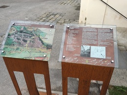
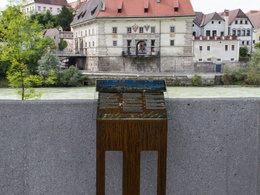
On this circular route, guests and Steyr residents are introduced to the beauty of Steyr am Nationalpark by means of the stylishly designed steles ...
On this circular route, guests and Steyr residents are introduced to the beauty of Steyr am Nationalpark by means of the stylishly designed steles ...
Quality of experience: ***
Recommended season:
- January
- February
- March
- April
- May
- June
- July
- August
- September
- October
- November
- December
Properties:
- Loop
- Cultural/historical value
These steles have been placed in excellent locations and briefly and concisely explain the most important points that can be seen from the viewing platforms.The panorama trail leads from Lamberg Castle to the Tabor Tower, along the Taborweg to the Uprimystiege, on via the Frauenstiege to the Museum Arbeitswelt and back to Lamberg Castle.
Directions:
The circular route can be walked in two variants. There is a north and a south loop.
Starting point: Lamberg Castle
Destination: Lamberg Castle
further information:
- Flatly

Barockkirche St. Michael

Dukartstraße

Ennsbrücke - Zwischenbrücken

Frautor

Friedhof - Jüdischer Friedhof

Kollertor
Museum Arbeitswelt

Museumssteg und Wendeltreppe

Neutor

Panoramalift und Aussichtssteg Steyr

Schiffmeisterhaus

Schloss Lamberg

Schlossgalerie Lamberg

Segway Steyr

Stadtgraben Steyr

Stadtmuseum Steyr

Stadtpfarrkirche Steyr

Steyr

Zusammenfluss Enns und Steyr
Most economical season
- Spring
- Summer
- Autumn
- Early winter
- Deep winter
Please get in touch for more information.
Stadtplatz 27
4400 Steyr
Phone +43 7252 53229 - 0
E-Mail info@steyr-nationalpark.at
Web www.steyr-nationalpark.at/
https://www.steyr-nationalpark.at/
Interactive elevation profile
Create PDF
Tour-Details
Starting place: 4400 Steyr
Destination: 4400 Steyr
duration: 1h 15m
length: 4,3 km
Altitude difference (uphill): 97m
Altitude difference (downhill): 91m
Lowest point: 287m
Highest point: 336m
difficulty: easy
condition: easy
panoramic view: Individual Views
Paths covering:
Asphalt, Path / trail, Street, Other
powered by TOURDATA