L2 Grenzweg
Path number: L2 - Grün
Starting place: 4262 Leopoldschlag
Destination: 4262 Leopoldschlag


Flatly
Marktplatz 1
4262 Leopoldschlag
4262 Leopoldschlag

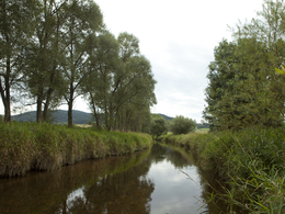
The circular route leads along the border river Maltsch (European nature reserve Natura 2000 and part of the European Green Belt), which we follow for about 3 kilometres. The area shows us its biodiversity, which was able to develop over decades as a result of the Iron Curtain;
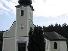
The hiking trail then runs along forest and meadow paths towards Stiegersdorf, where we turn into a farm track at a wayside shrine. Approx. 500 metres before the Wullowitz border crossing, we cross the main road (refreshments available at the Franzosenhof inn) and continue to Eisenhut. In Eisenhut, we turn onto the horse-drawn railway trail and follow it to Hiltschen. Remains of the horse-drawn railway can be seen on this section of the route. In Hiltschen (detour to the Maria Schnee pilgrimage church on the Hiltschnerberg - approx. 500m), we leave the horse-drawn railway trail and walk along an old hollow path with stone walls, past the Hafnerhaus, back to the starting point. Path number: L2 - Grün
Starting place: 4262 Leopoldschlag
Destination: 4262 Leopoldschlag
duration: 3h 19m
length: 12,6 km
Altitude difference (uphill): 148m
Altitude difference (downhill): 141m
Lowest point: 616m
Highest point: 719m
difficulty: medium
condition: medium
panoramic view: No view
Paths covering:
Asphalt, unfixed, Hiking trail, Other
Starting point: Hiking starting point Leopoldschlag (hiking boot, near Pension Hackermühle)
Destination: Hiking starting point Leopoldschlag (hiking boot, near Pension Hackermühle)
further information:
- Flatly
Most economical season
- Spring
- Summer
- Autumn
Please get in touch for more information.
Marktplatz 1
4262 Leopoldschlag
Phone +43 7949 8255
E-Mail anfrage@muehlviertel.at
Web www.leopoldschlag.ooe.gv.at/
Web www.muehlviertel-urlaub.at/wandern
https://www.leopoldschlag.ooe.gv.at/
https://www.muehlviertel-urlaub.at/wandern
https://www.muehlviertel-urlaub.at/wandern