

K36 Harterleitenweg


- Flatly
Interactive elevation profile
Create PDF
Tour-Details
Paths covering:
Wonderful circular tour with distant views of the Alps.
At the starting point on the market square in Kefermarkt, the mighty church with the world-famous winged altar immediately catches our eye.
However, we turn right and walk along the road towards Gutau and leave the road after a fish pond. Here you can regularly (usually on Fridays) buy freshly caught trout.
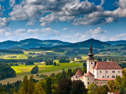
A short stretch along the Flanitz stream before heading uphill. When we reach the top, the weather is fine and we can enjoy the marvellous view for a while. We then head downhill again, first on country lanes, then on a quiet access road. At the bottom, we cross the district road and find ourselves in the Feldaisttal valley. From now on, we head upstream with a constant view of the village with its characteristic Weinberg Castle and church.
Through the village centre, we return to the starting point.
further information:
- Flatly
- Spring
- Summer
- Autumn
Please get in touch for more information.
Oberer Markt 15
4292 Kefermarkt
Phone +43 7947 5910 - 0
E-Mail gemeinde@kefermarkt.ooe.gv.at
Web www.kefermarkt.ooe.gv.at/
Web www.muehlviertel-urlaub.at/wandern
https://www.muehlviertel-urlaub.at/wandern
Interactive elevation profile
Create PDF
Tour-Details
Paths covering: