

PATH OF SALT - STAGE 2/1 HALLSTATT - BAD ISCHL


- pets allowed
- Suitable for families
Interactive elevation profile
Create PDF
Tour-Details
Paths covering:
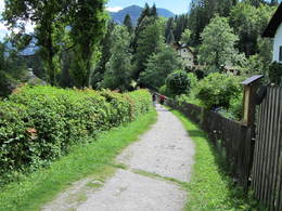
On the trail of the "white gold", this stage leads along the oldest pipeline in the world - the historic brine pipeline from Hallstatt to Bad Ischl. The 23-kilometre route runs through the impressive landscape of the Salzkammergut, always accompanied by the history of salt mining. With only 65 metres of ascent and 107 metres of descent, this approximately 5:45-hour hike is ideal for pleasure hikers who want to combine nature, culture and history.
Along the oldest pipeline in the world.
This stage follows the pipeline from Hallstatt to Ebensee, which first went into continuous operation in 1607. Firstly, take the boat from Hallstatt market to Hallstatt railway station. The route continues along the eastern shore of Lake Hallstatt to the Steegwirt (km 8.4) and from there the Soleweg leads via Bad Goisern, Laufen and Kaltenbach to the imperial town of Bad Ischl with the destination Trinkhalle (km 23.0).
POINTS OF INTEREST
Hallstätter Seeklause, "Neu Wildenstein" (forestry administration, 4822 Bad Goisern, Obere Marktstraße 1), Chorinskyklause (Weissenbach), Wilder Lauffen, "Kulturpfade" https://www.kulturpfade-badischl.at/salz/, Sudhaus Bad Ischl (Salinenplatz 1, 4820 Bad Ischl), Trinkhalle, Lehár-Villa Museum - Ischler Heimatverein.
Perneck salt mine: tunnel hut at Lipplesgraben gallery, mountain house at Ludovika gallery, mountain saw at Maria Theresia gallery, new mountain house at Maria Theresia gallery, brine clarification reservoir in the meadow near Leopold gallery, Franz mountain house at Franz gallery.
Experience a 360° panoramic tour through Bad Goisern on Lake Hallstatt...
further information:
- Experience of nature
By car
From Salzburg:
Exit Thalgau via the B158 federal road towards Bad Ischl, in Bad Ischl take the B145 Salzkammergut road towards Bad Goisern.
From Linz:
Regau motorway exit onto Salzkammergut Straße B145 towards Gmunden and Bad Ischl to Bad Goisern.
From Vienna/Graz:
Liezen motorway exit onto B320, in Trautenfels turn off onto Salzkammergut Straße B145 to Bad Goisern.
From Villach:
Tauern motorway to exit "Eben im Pongau", via B166 Pass Gschütt Bundesstraße through Gosau, turn left at the Gosaumühle junction towards Bad Goisern.
By train
Train Attnang-Puchheim - Stainach-Irdning:
Stops Goisern Jodschwefelbad, Bad Goisern railway station, Steeg / Gosau.
By bus
Bus 541 & 542 (Bad Ischl - Lake Gosau):
Stops Bad Goisern Jodschwefelbad, Bad Goisern Kurhotel, Bad Goisern Mitte/B145, Stambach StrKrzg., St. Agatha Agathawirt, Stambach Angerer, Steeg Reitern, Steeg Au, Steeg Bahnhof, Steeg Traunbrücke, Steeg E-Werk.
Detailed information on the respective Train- and Bus times can be found here!
- Free entry
- Suitable for groups
- Suitable for schools
- Pets allowed
- Suitable for teenagers
- Suitable for seniors
- Suitable for single travelers
- Suitable for families
- Suitable for friends
- Suitable for couples
- Suitable for children
- Spring
- Summer
- Autumn
Please get in touch for more information.
Kirchengasse 4
4822 Bad Goisern am Hallstättersee
Phone +43 5 95095 - 10
Fax machine +43 5 95095 - 74
E-Mail goisern@dachstein-salzkammergut.at
Web dachstein.salzkammergut.at
You can also visit us on
Visit us on Facebook Visit us on Instagram Visit us on TikTok Visit us on Pinterest Visit our videochannel on YouTube WikipediaInteractive elevation profile
Create PDF
Tour-Details
Paths covering: